The Swan and Canning Rivers have, from the earliest period of European settlement, been a focus of Western Australian life. Within the Swan/Canning River system, listed on the State Register of Heritage Places (Place Number P18987), there are historic vessels of significant heritage value located on or under the riverbed sediments.
This project, led by the Winwell Foundation, undertook subsurface acoustic surveys using parametric sub-bottom profiler technology to help characterise and document the buried material remains of four vessels either lost or abandoned in the Swan-Canning River system. The outcomes of the study provided vital information with which preliminary in-situ heritage management plans can be prepared by the Western Australian Museum.
Sub-bottom profiling (SBP) was used to collect high-resolution acoustic slices through the riverbed, allowing the team to interpret buried structure, cargo layers, and surrounding sediments without disturbance.
The datasets provided are volumetric gridded spatial point clouds in XYZM text file format, where X, Y, Z represent spatial coordinates and M represents acoustic intensity values. These files can be visualized on computers or in virtual reality headsets using the integrated viewer.
Data Collection: Data were collected using an Innomar 'Smart' SBP system, a parametric sub-bottom profiler that provides high-resolution imaging used to map fine-scale features. All SBP runs were recorded in .RAW format files and processed using Innomar's ISE V2.9.5.79 software package.
Data Processing: The Applecross dataset has been filtered to M values greater than 200, and the Bull Creek dataset to M values greater than 50, to reduce file sizes while preserving key features. See the R processing script for details. Complete raw datasets are available upon request from the Winwell Foundation.
Purpose: These datasets are provided as open data for training and educational purposes in maritime archaeology, geophysical survey methods, and 3D data visualization.
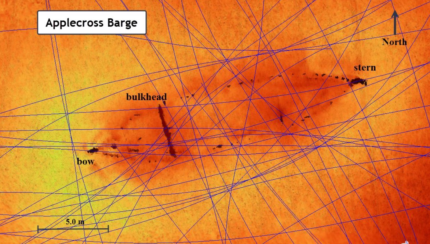
The Applecross Barge is currently under investigation by WAM after its discovery by MAAWA in October 2023. It is an unpowered barge about 21m long, with the rudder still intact and the main hull well buried to the waterline. Sub-bottom profiling revealed smooth planar cargo layers. The site's position and water depth are consistent with survivor information from the sinking of Jane (1897), which was returning to Perth having loaded a cargo of bricks from Cannington, when a severe gale was encountered. These conditions were safely weathered until the barge entered Melville Water, where it anchored overnight. The weather conditions worsened and threatened to sink the boat, so the crew of two began to throw bricks overboard, but after several hours of effort keeping it afloat, the barge sank.
Dataset filtered to M values > 200. Full raw dataset available on request.
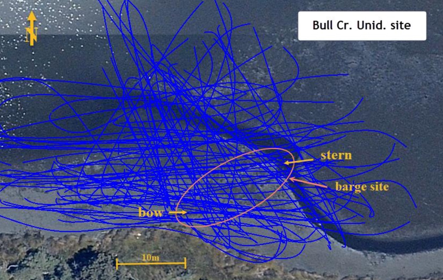
The Bull Creek unidentified wreck is a 20 x 3.9 m timber vessel abandoned in Bull Creek. The remnant frames and sternpost partially protrude from the mud and are visible at extreme low tide conditions. The hull is mostly buried under a mud bank of at least one meter thickness. The site was initially suspected to be the Dugong, believed to have been the first vessel built, with convict labour, on the Canning River in 1894. However, SBP surveys determined it is a flat-bottomed barge, and based on all lines of evidence, it would appear likely that the unidentified barge at the Head of Bull Creek was once owned and subsequently abandoned by the Bateman family.
Dataset filtered to M values > 50. Full raw dataset available on request.
Profile slices: Run 133801 (aft cross-section showing a flat near-contiguous reflector) and Run 143409 (amidships cross-section with a slight reflector incline and isolated bow reflectors) are provided as interpolated voxel exports. Run 133801 Download / Preview — Run 143409 Download / Preview.
The wreck of a barge sunk with a cargo of limestone at Point Walter, discovered in 2023, was formally identified in July 2024 by the Western Australian Museum as Dearden's flat. This vessel was lost in 1882 and is now registered as a maritime archaeological site under Section 4.1.(a) of the Maritime Archaeology Act 1973. The site is historically significant as the oldest known wreck located in the Swan River. The site is uniquely and highly archaeologically significant, with the vessel's construction, cargo and general equipment still mostly intact, in contrast to most similar wrecks which were stripped before abandonment.
Full dataset coming soon.

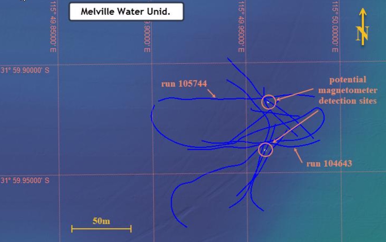
Scrimshaw (1980) reported that a wreck surveyed in 1896 was annotated on an Admiralty Chart published in 1904. This wreck was depicted in Melville Water between Dundas and Pelican Point, as a hazard to navigation, and thus presumed to be more than a leisure vessel. Divers from MAAWA searched the site without success, and a follow-up echo sounding survey conducted in 1979 failed to identify any wreckage on the riverbed surface. In October 2018, the WA Museum identified several magnetic anomalies at the site, indicating the potential for buried material. Subsurface surveys conducted in 2025 did not locate any buried remains, though magnetometer records indicate potential for buried ferrous material requiring further investigation.
Full dataset coming soon.